Image illustrating the map of Indonesia
Comparedoo
Image illustrating the map of Angola
Header top banner ads

Indonesia vs Angola (Statistical Comparison)

Published: Monday, 21th October 2024

Recently Updated: Thursday, 10th April 2025

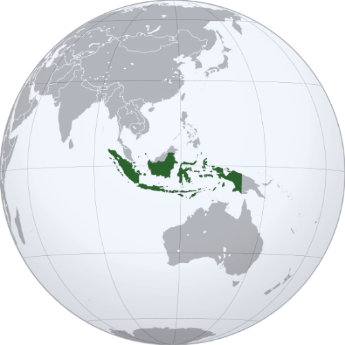
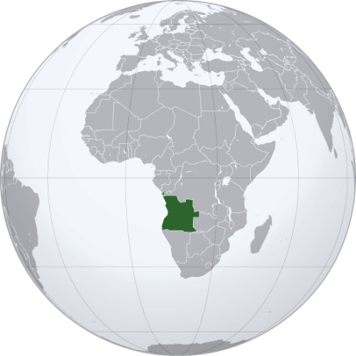
Comparedoo.com welcomes you to explore the detailed comparison between Indonesia and Angola.
Dive in and compare them across different aspects like cost of living, standard of living, geography, demographics, environment, society, economy, health factors and many more.
Enjoy exploring!

Header top banner ads

Pictorial Representation

Indonesia
Map in Globe
Pictorial representation of the map of Indonesia in the world map
Map
Pictorial representation of map of Indonesia
Flag
Image illustrating the flag of Indonesia
Coat of Arms
Image showing the coat of arms of Indonesia
Angola
Map in Globe
Pictorial representation of the map of Angola in the world map
Map
Pictorial representation of map of Angola
Flag
Image illustrating the flag of Angola
Coat of Arms
Image showing the coat of arms of Angola
Image representing an indicator
Indicators
Image illustrating an indicator
Pictorial representation of map of indonesia
Indonesia
Image illustrating the flag of indonesia
Pictorial representation of map of angola
Angola
Image illustrating the flag of angola
Official Name
Visual representation of official name of any country
Republic of IndonesiaRepublic of Angola
Continent
Visual representation of all continents in the world
AsiaAfrica
Landlocked Status
Image Depicting whether the status is landlocked or not.
Not LandlockedNot Landlocked
Capital City
Visual representation of a capital city of any specific country
JakartaLuanda
Latitude
Image Depicting Latitide lines in World Map
5° 0′ 0″ S12° 30′ 0″ S
Longitude
Image Depicting Longitude lines in World Map
120° 0′ 0″ E18° 30′ 0″ E

Size Comparison

The total area of Indonesia is 1,904,569 sq km, and the total area of Angola is 1,246,700 sq km. Indonesia is bigger than Angola by 657,869 sq km. Indonesia is around 1.53 times bigger than Angola.

Image representing an indicator
Indicators
Image illustrating an indicator
Pictorial representation of map of indonesia
Indonesia
Image illustrating the flag of indonesia
Pictorial representation of map of angola
Angola
Image illustrating the flag of angola
Area in Square Kilometers
Illustration of area in Square Kilometers
1,904,569 Sq km1,246,700 Sq km
Difference [ 657,869 Square Kilometers]
Area in Square Mile
Illustration of area in Square Mile
735,358 Sq Mile481,400 Sq Mile
Difference [ 253,958 Square Mile]
Water % in Area
Illustration of water percentage area of any country in the world
4.85 %Negligible
Header top banner ads

Geographical Factors Comparison

Image representing an indicator
Indicators
Image illustrating an indicator
Pictorial representation of map of indonesia
Indonesia
Image illustrating the flag of indonesia
Pictorial representation of map of angola
Angola
Image illustrating the flag of angola
Largest City
Visual representation of the Largest City of any country
JakartaLuanda
Demonyms
Image depicting demonyms of any specific country
IndonesianAngolan
Official Languages
Image depicting the official languages of any specific country
IndonesianPortuguese
Government Status
Image indicating the government status of any country
Unitary presidential republicUnitary dominant-party presidential republic
Major Religion
Image indicating the major religion of any country
IslamChristianity
Major Religion Percentage
Image indicating the major religion percentage of any country
87.06 %92.9 %

The people of Indonesia are called Indonesian, and the people of Angola are called Angolan.

Image representing an indicator
Indicators
Image illustrating an indicator
Pictorial representation of map of indonesia
Indonesia
Image illustrating the flag of indonesia
Pictorial representation of map of angola
Angola
Image illustrating the flag of angola
Currency Name
Visual representation of currency name of any specific country
Indonesian rupiahAngolan kwanza
Currency Symbol
Visual representation of currency symbol of any specific country
IDRAOA
Driving Side
Visual representation of driving side of any specific country
LeftRight
Calling Code
Image depicting calling code of any specific country
+62+244
Internet TLD
Image depicting Internet Top Level Domain also called tld of any specific country
.id.ao
Start of Week
Image showing the first working day of week of any specific country
SundayMonday
ISO 3166 Code
Image depicting ISO 3166 Code of any specific country
IDAO
Header top banner ads

National Symbols Comparison

Image representing an indicator
Indicators
Image illustrating an indicator
Pictorial representation of map of indonesia
Indonesia
Image illustrating the flag of indonesia
Pictorial representation of map of angola
Angola
Image illustrating the flag of angola
National Anthem Title (Native)
Visual representation of national anthem of any country in their native language
Indonesia RayaAngola Avante
National Anthem Title (In English)
Visual representation of national anthem of any country in English language
Indonesia the GreatOnwards Angola
National Animal
Visual representation of national animal of any specific country
Komodo DragonSable Antelope
National Bird
Visual representation of national bird of any specific country
Javan Hawk-EagleRed-crested Turaco
National Flower
Visual representation of national flower of any specific country
Melati PutihWelwitschia
National Sport
Visual representation of national sport of any specific country
BadmintonCapoeira
National Colors
Visual representation of national colors of any specific country
Red and whiteRed, black and yellow
Header top banner ads

Time Differences Comparison

Image representing an indicator
Indicators
Image illustrating an indicator
Pictorial representation of map of indonesia
Indonesia
Image illustrating the flag of indonesia
Pictorial representation of map of angola
Angola
Image illustrating the flag of angola
Current Date
Visual representation of current date of any specific country
Yet to UpdateYet to Update
Current Time
Visual representation of current time of any specific country
Yet to UpdateYet to Update
Timezones
Visual representation of timezones of any specific country
UTC+7 to +9 (various)
UTC+1 (West Africa Time)
Current Timezone
Visual representation of current timezone of any specific country
UTC+7 to +9 (various)
UTC+1 (West Africa Time)
Daylight Saving Time
Visual representation of Daylight Saving Time of any specific country
DST Not ObservedDST Not Observed
Daylight Saving Time Start
Visual representation of Daylight Saving Time Start of any specific country
DST Not ObservedDST Not Observed
Daylight Saving Time End
Visual representation of Daylight Saving Time End of any specific country
DST Not ObservedDST Not Observed
Daylight Saving Time Duration
Visual representation of Daylight Saving Time Duration of any specific country
DST Not ObservedDST Not Observed
Header top banner ads

Population Comparison

Based on the elaboration of latest World Bank Data, the total population of Indonesia as of 2023 is estimated to be around 277,534,122, and the total population of Angola as of 2023 is estimated to be around 36,684,202.

As per the above data, we can say that in the year 2023, Indonesia had 240,849,920 more people than Angola.

Pictorial representation of map of indonesia
Indonesia
Image illustrating the flag of indonesia
Population Graph (2013-2023)
Pictorial representation of map of angola
Angola
Image illustrating the flag of angola
Population Graph (2013-2023)

The annual Population Growth in Indonesia is 0.92% and the annual population growth in Angola is 3.44%.

Header top banner ads

Age Distribution of Population

Image representing an indicator
Indicators
Image illustrating an indicator
Pictorial representation of map of indonesia
Indonesia
Image illustrating the flag of indonesia
Pictorial representation of map of angola
Angola
Image illustrating the flag of angola
Age ( 0 - 14 )
(Year: 2023)
Image of a Teenage Girl
17 % 30.1 %
Age ( 15 - 64 )
(Year: 2023)
Image of an Adult Woman
76.4 %67.4 %
Age ( 65+ )
(Year: 2023)
Image of a Older Aged Woman
6.53 %2.5 %
Header top banner ads

Weather Comparison

Image representing an indicator
Indicators
Image illustrating an indicator
Pictorial representation of map of indonesia
Indonesia
Image illustrating the flag of indonesia
Pictorial representation of map of angola
Angola
Image illustrating the flag of angola
[ LATEST WEATHER DATA ]
Place
Visual representation of place of any country
Yet to Update Yet to Update
Current Time
Visual representation of current time of any specific country
Yet to UpdateYet to Update
Current Weather
Visual representation of current weather of any specific place in a country
Yet to UpdateYet to Update
Current Temperature
Visual representation of current temperature of any specific place in a country
Yet to UpdateYet to Update
Wind Speed
Visual representation of Speed of Wind Flowing of any specific place in a country
Yet to UpdateYet to Update
Humidity
Visual representation of Humidity of any specific place in a country
Yet to UpdateYet to Update
Header top banner ads

Health Factors Comparison

Image representing an indicator
Indicators
Image illustrating an indicator
Pictorial representation of map of indonesia
Indonesia
Image illustrating the flag of indonesia
Pictorial representation of map of angola
Angola
Image illustrating the flag of angola
Fertility Rate
(2023)
Image representation of Fertility rate or ratio of any given country
2.15
(Births Per Woman)
5.21
(Births Per Woman)
Mortality Rate (Adult Male)
(2023)
Image representation of Death rate or Mortality rate of adult male any given country
232.3
(Per 1000 Male Adults)
323.66
(Per 1000 Male Adults)
Mortality Rate (Adult Female)
(2023)
Image representation of Death rate or Mortality rate of adult female any given country
169.93
(Per 1000 Female Adults)
222.86
(Per 1000 Female Adults)
Infant Mortality Rate
(2023)
Image representation of Infant Mortality Rate of any given country
18.1
(Per 1000 Live Births)
45.7
(Per 1000 Live Births)
Header top banner ads
Image representing an indicator
Indicators
Image illustrating an indicator
Pictorial representation of map of indonesia
Indonesia
Image illustrating the flag of indonesia
Pictorial representation of map of angola
Angola
Image illustrating the flag of angola
Top Cause of Death
(2023)
Image representation of top cause of death of any given country
Stroke
(
132 people per 100K population)
Neonatal conditions
(
97.6 people per 100K population)
Lowest Cause of Death
(2023)
Image representation of lowest cause of death of any given country
Neonatal conditions
(
17 people per 100K population)
Congenital anomalies
(
23.3 people per 100K population)
Road Traffic Deaths
(2023)
Image representation of road accident death of any given country
11.3
(people per 100K population)
15
(people per 100K population)
Suicide Deaths
(2023)
Image representation of number of suicide deaths of any given country
2.42
(Number of suicide deaths per 100K people)
6.08
(Number of suicide deaths per 100K people)
New HIV Infections
(2023)
Image representation of new HIV Infections of any given country
0.09
(HIV infections per 1000 people)
0.44
(HIV infections per 1000 people)

The leading cause of death in Indonesia, is [ Stroke ]. Around 132 people per 100,000 people in Indonesia, are dying of Stroke.

Similarly, around 97.6 people per 100,000 people in Angola, are dying of Neonatal conditions, as it is the leading cause of death in there.


The government of Indonesia, spent [ 3.71% ] of the amount of the Gross Domestic Product (GDP) in health sectors in the year 2023.

Likewise, the government of Angola, spent [ 2.96% ] of the amount of the Gross Domestic Product (GDP) in health sectors in the year 2023.

Header top banner ads
Image representing an indicator
Indicators
Image illustrating an indicator
Pictorial representation of map of indonesia
Indonesia
Image illustrating the flag of indonesia
Pictorial representation of map of angola
Angola
Image illustrating the flag of angola
Prevalance Of Hypertension
(2023)
Visual representation of prevalance of hypertension ratio of any given country
40.3
(Percentage of adults [30-79] with hypertension)
38.7
(Percentage of adults [30-79] with hypertension)
Adult Obesity
(2023)
Visual representation of obesity ratio of any given country
11.2%
(Percentage of Obesity in adults)
11.5%
(Percentage of Obesity in adults)
Pure Alcohol Consumption
(2023)
Visual representation of pure alcohol consumption ratio of any given country
0.11 Liters
(per adult over a calendar year)
6.17 Liters
(per adult over a calendar year)
Tobacco Consumption
(2023)
Visual representation of tobacco consumption ratio of any given country
40%
(Used by people aged 15 and above)
Yet to Update

As per the data from the World Health Organization (WHO), people living in Indonesia, are 1.03 times less likely to be obese compared to the people living in Angola.

We hope you enjoyed the detailed guide on the general comparison between Indonesia and Angola.

For more side-by-side comparsion between Countries, States and Cities, you can use the search box above or click the links below.

The Comparedoo.com family sincerely appreciates your time with us. We look forward to seeing you on our other pages.

Pictorial representation of the map of Indonesia
Indonesia
v/s
Dominican Republic
Pictorial representation of the map of Dominican Republic
Pictorial representation of the map of Indonesia
Indonesia
v/s
Italy
Pictorial representation of the map of Italy
Pictorial representation of the map of Indonesia
Indonesia
v/s
Qatar
Pictorial representation of the map of Qatar
Pictorial representation of the map of Indonesia
Indonesia
v/s
Papua New Guinea
Pictorial representation of the map of Papua New Guinea
Pictorial representation of the map of Indonesia
Indonesia
v/s
North Korea
Pictorial representation of the map of North Korea
Pictorial representation of the map of Indonesia
Indonesia
v/s
Nigeria
Pictorial representation of the map of Nigeria
Pictorial representation of the map of Indonesia
Indonesia
v/s
Sao Tome and Principe
Pictorial representation of the map of Sao Tome and Principe
Pictorial representation of the map of Indonesia
Indonesia
v/s
Sri Lanka
Pictorial representation of the map of Sri Lanka
Pictorial representation of the map of Indonesia
Indonesia
v/s
Eritrea
Pictorial representation of the map of Eritrea
Pictorial representation of the map of Indonesia
Indonesia
v/s
Luxembourg
Pictorial representation of the map of Luxembourg
Pictorial representation of the map of Indonesia
Indonesia
v/s
Mali
Pictorial representation of the map of Mali
Pictorial representation of the map of Indonesia
Indonesia
v/s
Togo
Pictorial representation of the map of Togo